

Cervest - Climate Intelligence Platform#
Duration: June 2021 - June 2023 Location: Berlin, Germany
Why This Matters#
Flood risk is one of the most financially significant climate hazards, yet most available flood data is either too coarse for asset-level decisions or too expensive to produce at global scale. This project tackled that gap — delivering a high-resolution, multi-scenario flood risk dataset that enables insurers, asset managers, and governments to quantify flood exposure anywhere on Earth.
Impact#
- Delivered a global 90 m resolution flood risk dataset covering both riverine and pluvial flooding
- Multi-scenario coverage: return periods from 2 to 1000 years across historical and RCP climate scenarios
- Used commercially for climate risk assessment
- Provided foundation for Cervest’s climate intelligence platform
Project Overview#
Co-architected and built a globally-scoped riverine and pluvial flood risk system that produces 90 m resolution inundation maps across multiple climate scenarios and return periods. The system combines physics-based hydraulic modelling, Bayesian statistical inference, and high-performance geospatial downscaling, orchestrated at scale via Argo Workflows on Kubernetes.
Technical Deep Dive#
Riverine Flooding#
The riverine pipeline computes flood risk end-to-end — from raw climate model discharge data to actionable inundation depth maps:
Bathtub Flood Inundation Model (Julia) — I built the core algorithm that converts flood volumes into flood depths across a landscape. Given a known flood volume for a river reach, the model fills the surrounding floodplain from the lowest elevation upward using the HAND (Height Above Nearest Drainage) metric as a proxy for relative elevation above the river channel. The model classifies pixels by flood susceptibility and integrates with global water masks for accurate inundation mapping.
Multi-Resolution Downscaling with Volume Conservation — Spatial downscaling from coarse climate model outputs to 90 m inundation depth maps, with volume conservation accounting for latitude-dependent pixel area. The approach captures fine-scale terrain features such as levees and embankments.
Hydrological Network Analysis — Strahler stream order extraction, HAND computation, and sub-basin delineation using pyflwdir. Long basins are cut at intermediate outlets to keep computational units memory-efficient while preserving hydrologic coherence. Basin edge masking removes incomplete basins at tile boundaries to prevent artefacts.
Bayesian Bias Correction — ISIMIP climate model discharge projections are bias-corrected against historical GLOFAS observations using Stan-based Bayesian quantile mapping. Gumbel (extreme value) distributions are fitted to annual maximum discharge series via MCMC inference, producing uncertainty-quantified return levels at the 5th, 50th, and 95th percentiles.
Physics-Based Hydraulic Modelling — Flood volumes computed using Manning’s equation for open-channel flow, with empirical relationships for river geometry (width, depth, slope) derived from upstream catchment area. The model accounts for channel vs. floodplain friction, river sinuosity, and Strahler stream order.
Pluvial Flooding#
RichDEM.jl — Julia Bindings for Fill-Spill-Merge#
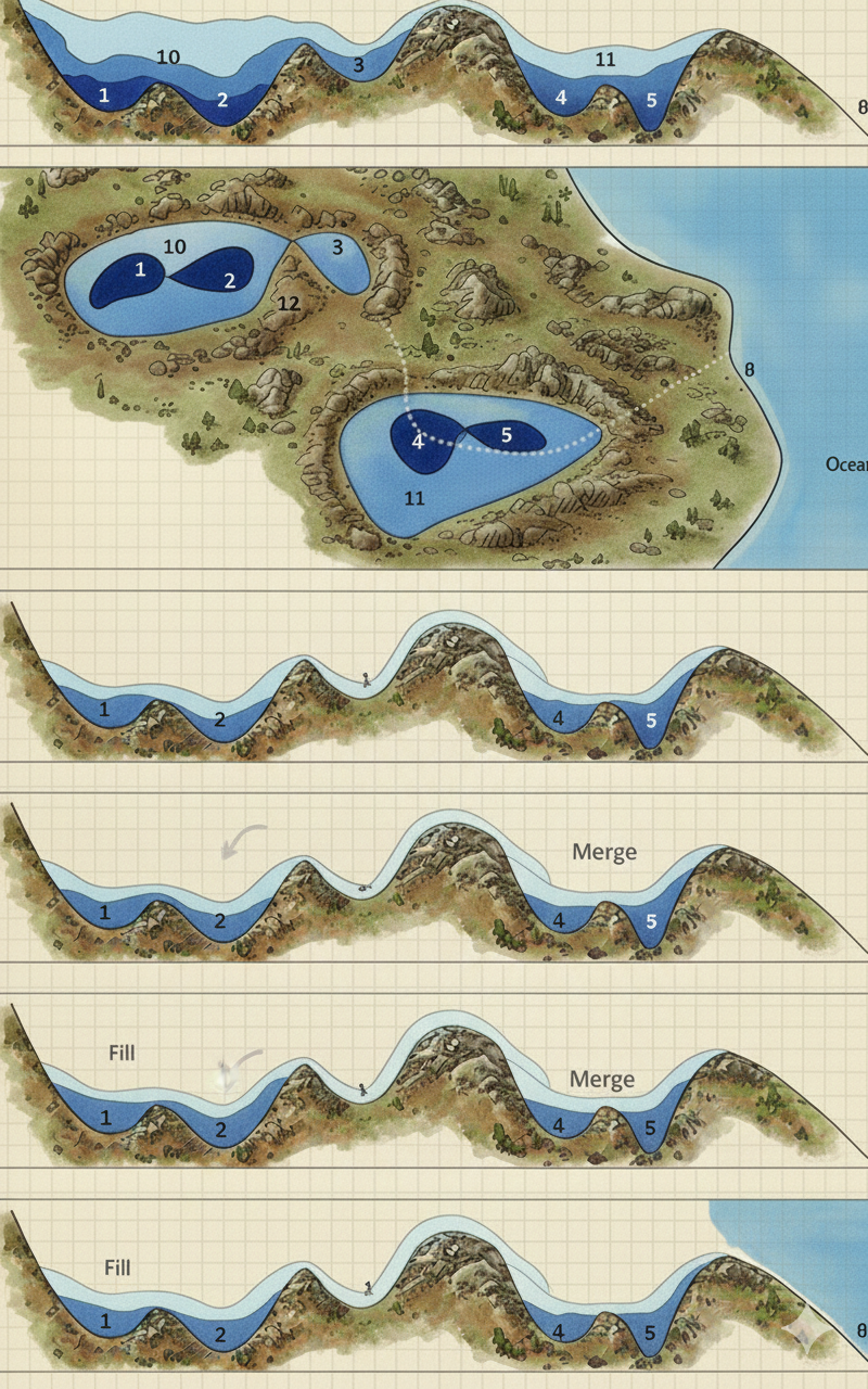
I created RichDEM.jl, Julia language bindings for the C++ RichDEM library, using CxxWrap.jl. This made the high-performance Fill-Spill-Merge algorithm and core data structures available in Julia for pluvial flood modelling:
- Wrapped C++ classes (Array2D, DepressionHierarchy) with proper template handling for float/double types
- Exposed the BucketFillFromEdges algorithm to Julia
- Built the RichDEM_jll binary dependency and the RichDEM.jl package
- Set up a containerised development environment with Docker and VSCode integration
- Fixed bugs in the core C++ library (indexing, data type handling)
This enabled depression hierarchy computation from elevation data, which fed into rainfall-scenario-driven pluvial inundation modelling with serialised (compressed JSON) depression data stored on S3.
Performance Engineering for Global Scale#
Making these pipelines process the entire globe required significant performance work:
- DiskArrays broadcasting — Dramatically reduced raster computation times by leveraging lazy broadcasting over memory-mapped arrays
- Memory-mapped raster access — Enabled processing of very large tiles without loading them entirely into RAM
- Zstandard compression — Balanced I/O speed and storage for serialised geospatial arrays
- StructArrays — Cache-friendly, column-oriented storage for lookup tables
- Unitful.jl — Compile-time dimensional analysis preventing unit mismatch bugs
- Idempotent task generation — Workflows can be safely restarted after Kubernetes evictions
- Resource tuning — Iterative optimisation of memory limits, parallelism, and retry strategies for cloud-scale processing
Engineering#
Dual-Language Architecture#
| Language | Role |
|---|---|
| Python | Data ingestion, statistical modelling, orchestration, export |
| Julia | High-performance geospatial downscaling, bathtub flood model |
Migration from Pachyderm to Argo Workflows#
Led the migration of the entire pipeline from Pachyderm to Argo Workflows on Kubernetes:
- Rewrote task generation for Argo’s parallelism patterns
- Created workflow definitions for all pipeline stages
- Introduced idempotent reruns with success-tracking directories
- Highly parallel workflows with retry strategies
Infrastructure#
- Multi-stage Docker builds for Python and Julia containers
- CI/CD with GitHub Actions (black, isort, flake8, mypy, JuliaFormatter)
- Pre-commit hooks for both languages
- S3-based data storage with Zarr and Parquet export
- H3 hexagonal indexing for downstream query APIs
Technical Stack#
Languages: Julia, Python
Geospatial: ArchGDAL, pyflwdir, whitebox-tools, GDAL, Rasterio
Statistical: CmdStanPy, Stan (Bayesian MCMC)
Data Formats: GeoTIFF, Zarr, Parquet, NetCDF
Infrastructure: Docker, Argo Workflows, Kubernetes, AWS S3
Julia Libraries: DiskArrays, StructArrays, Unitful.jl, CxxWrap.jl
Technologies: Julia, Python, Stan, Argo Workflows, Kubernetes, Docker, Geospatial Processing
Domain: Climate tech, Flood hydrology, Extreme value statistics, Distributed computing